Volcanoes near plate boundaries
Volcanic arcs often form above subduction zones, offset inland from their trenches. Volcanoes also occur along spreading systems where magma rises as plates separate.
Locate documented volcanoes and compare their settings with the plate network.
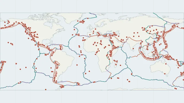
Volcanic arcs often form above subduction zones, offset inland from their trenches. Volcanoes also occur along spreading systems where magma rises as plates separate.
Hawaii demonstrates volcanism within a plate. Its chain is associated with a hotspot, so proximity to a plate boundary is not a requirement for a volcano.
The displayed locations come from NOAA NCEI's Global Volcano Locations Database. Labels such as Historical and Radiocarbon describe catalogue evidence, not current eruption status. For an eruption today, check a dated report from the responsible volcano observatory.
Plate outlines use Peter Bird's PB2002 model, distributed by Nordpil under the Open Data Commons Attribution licence. Coastlines and country outlines are Natural Earth public-domain data. Boundary detail is limited by the source model. Volcano locations use the NOAA NCEI catalogue, originating from Smithsonian GVP. The layer describes locations and historical evidence, not current eruptions.
Country lookup compares simplified land outlines with the plate model. Boundaries and historical coastlines are modelled features. This atlas explains geography; it does not predict earthquakes or provide site-specific hazard estimates.