Hotspots versus boundary volcanoes
A hotspot is a persistent region of volcanism that can occur within a plate. Some hotspots interact with spreading ridges, so hotspot and boundary settings can overlap.
Compare volcanic hotspots with volcanoes along plate boundaries.
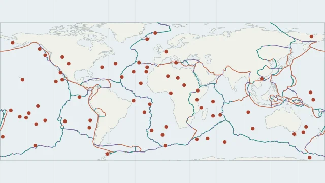
A hotspot is a persistent region of volcanism that can occur within a plate. Some hotspots interact with spreading ridges, so hotspot and boundary settings can overlap.
The Hawaiian chain records volcanism as the Pacific Plate moved relative to a mantle source. Older islands and seamounts extend away from the youngest end of the chain.
Hotspots are useful reference points, but they are not necessarily fixed forever. Their origin, depth and motion vary, and a hotspot point does not describe the full magma system.
Plate outlines use Peter Bird's PB2002 model, distributed by Nordpil under the Open Data Commons Attribution licence. Coastlines and country outlines are Natural Earth public-domain data. Boundary detail is limited by the source model.
Country lookup compares simplified land outlines with the plate model. Boundaries and historical coastlines are modelled features. This atlas explains geography; it does not predict earthquakes or provide site-specific hazard estimates.