Continents versus tectonic plates
A continent describes a large landmass; a tectonic plate includes crust and rigid upper mantle. Their edges usually differ. The coastline marks the waterline, not the edge of continental crust.
Compare familiar land outlines with the tectonic plates that continue beneath the oceans.
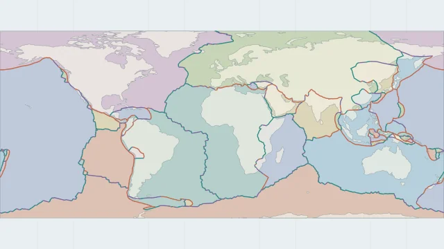
A continent describes a large landmass; a tectonic plate includes crust and rigid upper mantle. Their edges usually differ. The coastline marks the waterline, not the edge of continental crust.
Many plates carry both continental and oceanic crust. Continental shelves extend underwater, so an offshore part of a plate cannot be classified as oceanic crust from the coastline alone.
Follow the South American Plate east from Brazil across the Atlantic to the Mid-Atlantic Ridge. Its western edge lies near the Andes, where the Nazca Plate descends beneath South America.
No. A continent can cross plate boundaries, and a plate can extend beneath a continent and its neighbouring ocean.
Land and plate outlines alone do not identify crust type. A geological crust dataset is needed to locate the continental-oceanic transition.
WATCH THE MAP EXPLAINED
See why plate outlines differ from continents and how their boundaries move.
Watch on YouTube ↗Plate outlines use Peter Bird's PB2002 model, distributed by Nordpil under the Open Data Commons Attribution licence. Coastlines and country outlines are Natural Earth public-domain data. Boundary detail is limited by the source model.
Country lookup compares simplified land outlines with the plate model. Boundaries and historical coastlines are modelled features. This atlas explains geography; it does not predict earthquakes or provide site-specific hazard estimates.